Understanding the sky is crucial for any outdoor enthusiast, especially those involved in activities like surfing, skiing, and mountaineering. Weather conditions can change rapidly, and the ability to interpret cloud patterns can mean the difference between a perfect day and a dangerous situation. This crash course will help you decode the sky and make informed decisions for your adventures.
## Cloud Basics

Clouds are formed when warm, moist air rises and cools, causing the water vapor to condense into visible droplets or ice crystals. These clouds can provide valuable clues about the current and upcoming weather conditions.
## Cloud Types
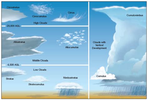
### Cumulus Clouds
Cumulus clouds are fluffy and white, often appearing as cotton balls. They indicate fair weather but can also indicate the start of a weather system. Look for a “mushroom” shape with a flat base, which may suggest an approaching storm.
### Cumulonimbus Clouds
These towering clouds have a dark, ominous appearance and are often associated with severe weather. They can bring thunderstorms, heavy rain, hail, and lightning. If you see cumulonimbus clouds, it’s time to seek shelter.
### Stratus Clouds
Stratus clouds are gray and flat, covering the entire sky. They bring overcast conditions and can bring light to moderate rain or snow. These clouds usually indicate stable conditions, but they can also be a sign of a slow-moving front.
### Cirrus Clouds
Cirrus clouds are thin, wispy, and often seen at higher altitudes. They can indicate a coming warm front, but they can also signal the end of a weather system. Generally, cirrus clouds are a sign of fair weather.
### Cirrostratus Clouds
These clouds are thin and gray, covering the entire sky. They often indicate a coming cold front and can bring rain or snow. They are similar to stratus clouds but are associated with colder weather.
## Interpreting Cloud Patterns
### The “Cloud Stack”
By observing the cloud stack, you can get a general idea of the weather conditions. The cloud stack consists of the following layers, from lowest to highest:
1. **Surface**: Low clouds like stratus and stratocumulus.
2. **Middle**: Clouds like altostratus and altocumulus.
3. **High**: Clouds like cirrus and cirrostratus.
The presence of high clouds (cirrus and cirrostratus) often indicates a stable weather pattern, while the presence of middle and low clouds suggests more active weather conditions.
### The “Mushroom Cloud”
The “mushroom cloud” is a classic sign of a developing cumulonimbus cloud. If you see this pattern, prepare for the possibility of severe weather.
### The “Curtain of Rain”
A curtain of rain, often associated with stratus clouds, indicates light to moderate rain or snow. This can be a good sign for water sports like surfing and skiing, but it’s essential to stay aware of changing conditions.
## Final Thoughts
Interpreting cloud patterns is an essential skill for anyone involved in outdoor activities. By understanding the different types of clouds and their associated weather conditions, you can make informed decisions and stay safe on your adventures. Remember, the sky is always a good predictor of what’s to come, so keep an eye on the clouds and stay prepared!