In the vast expanse of the mountainous terrains, nature’s own weather forecasters often reveal their insights through the enigmatic patterns of clouds. Among these, lenticular clouds stand out as harbingers of potential storms, serving as a critical tool for weather forecasting in mountainous regions. This article delves into the significance of lenticular clouds in predicting stormy weather and their role in mountain weather forecasting.
## The Nature of Lenticular Clouds

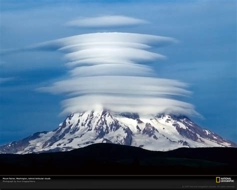
Lenticular clouds, also known as “wind-rotated clouds,” are lens-shaped formations that are typically observed at high altitudes, where the clouds are formed by the interaction of strong winds and stable air layers. These clouds can appear as smooth, convex structures, often resembling the convex surface of a lens. They are most commonly seen over mountain ranges, where they are formed by the orographic lift caused by the air being forced to rise over the elevated terrain.
## Predicting Storms with Lenticular Clouds
Lenticular clouds are often a precursor to stormy weather in mountainous areas. When these clouds form, it indicates that the conditions are ripe for severe weather events. Here are some reasons why lenticular clouds are significant in predicting storms:
### 1. High Altitude Winds
The formation of lenticular clouds is closely associated with strong winds at high altitudes. These winds can carry moisture and instability upwards, leading to the development of storms.
### 2. Air Mass Instability
The interaction of warm, moist air with cold, dry air can lead to the development of unstable air masses. Lenticular clouds often indicate the presence of such unstable air masses, which are conducive to storm formation.
### 3. Orogenic Lift
The lifting of air over mountainous terrain can cause the clouds to form in a lenticular shape. This process is often associated with the development of storms, as the rising air cools and condenses, leading to cloud formation and, potentially, precipitation.
## Role in Mountain Weather Forecasting
Mountain weather forecasting relies heavily on observing and interpreting the various signs of atmospheric activity. Lenticular clouds, with their unique characteristics, play a crucial role in this process:
### 1. Warning System
Meteorologists use the presence of lenticular clouds as a warning sign for potential stormy weather. By observing these clouds, they can provide timely warnings to the public and relevant authorities.
### 2. Data Collection
Lenticular clouds can also serve as a valuable source of data for meteorologists. By studying their formation and behavior, researchers can gain insights into the dynamics of atmospheric processes in mountainous regions.
### 3. Improved Forecast Accuracy
With the aid of lenticular clouds, meteorologists can improve the accuracy of their forecasts for mountainous areas. This is particularly important for activities such as hiking, skiing, and aviation, which are highly sensitive to weather conditions.
In conclusion, lenticular clouds are not just a fascinating meteorological phenomenon but also a valuable tool for weather forecasting in mountainous regions. By reading the signs these clouds provide, meteorologists can better predict and prepare for stormy weather, ultimately ensuring the safety and well-being of those who venture into the mountains.