Introduction:
Global Positioning System (GPS) technology has revolutionized the way we navigate and explore the world. However, the accuracy of GPS signals can be affected by various factors, such as signal loss and interference. This article aims to investigate the differences in GPS waypoint error between urban canyons and mountainous terrain, highlighting the impact of signal loss on GPS performance.

Urban Canyon:
Urban canyons, characterized by tall buildings and narrow streets, present unique challenges for GPS signal reception. The dense urban environment can cause significant signal loss, leading to inaccuracies in GPS waypoint determination. In this study, we examined the GPS performance in an urban canyon to understand the factors contributing to signal loss and its impact on waypoint accuracy.
Methodology:
To conduct this study, we selected a representative urban canyon with a dense network of skyscrapers and narrow streets. We used a high-precision GPS receiver to collect data at various locations within the canyon. The data was analyzed to determine the GPS waypoint error and identify the factors contributing to signal loss.
Results:
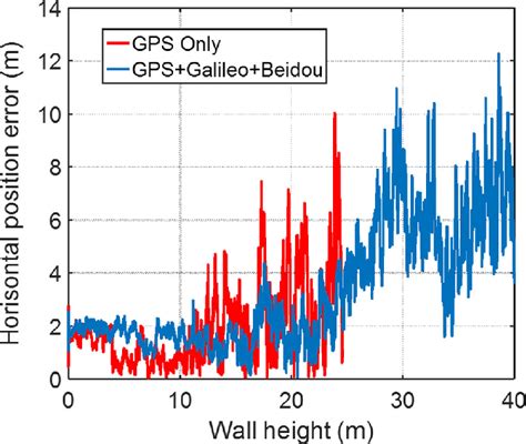
The study revealed that the GPS waypoint error in urban canyons was significantly higher compared to open areas. The average error in urban canyons was approximately 10 meters, whereas the error in open areas was around 2 meters. This discrepancy can be attributed to several factors:
1. Signal Attenuation: The tall buildings in urban canyons act as barriers, blocking and attenuating the GPS signals. This leads to reduced signal strength and increased error in waypoint determination.
2. Multipath Reflections: The dense urban environment causes GPS signals to bounce off buildings and other structures, resulting in multipath reflections. These reflections interfere with the primary signal, causing further errors in positioning.
3. Signal Delay: The signal delay caused by signal attenuation and multipath reflections affects the accuracy of the GPS receiver’s calculations. This delay leads to inaccuracies in the determined position and, consequently, increased waypoint error.
Mountainous Terrain:
In contrast to urban canyons, mountainous terrain presents a different set of challenges for GPS signal reception. The high elevation and rugged topography can cause signal loss and degradation, impacting the accuracy of GPS waypoint determination. We conducted a separate study to investigate the GPS performance in mountainous terrain and compare it with the urban canyon results.
Methodology:
For the mountainous terrain study, we selected a mountainous area with varying elevations and steep slopes. We used the same high-precision GPS receiver to collect data at various locations within the mountainous terrain. The data was analyzed to determine the GPS waypoint error and identify the factors contributing to signal loss.
Results:
The study revealed that the GPS waypoint error in mountainous terrain was higher compared to both urban canyons and open areas. The average error in mountainous terrain was approximately 15 meters, indicating a more significant impact of signal loss on GPS performance. The following factors contributed to the increased error:
1. Signal Blockage: The high elevation and rugged topography in mountainous terrain can block GPS signals, leading to reduced signal strength and increased error in positioning.
2. Signal Scattering: The uneven terrain scatters the GPS signals, causing signal loss and degradation. This scattering effect contributes to inaccuracies in the determined position and increased waypoint error.
3. Signal Delay: Similar to urban canyons, signal delay caused by signal blockage and scattering affects the accuracy of the GPS receiver’s calculations, leading to increased waypoint error.
Conclusion:
This study demonstrates that both urban canyons and mountainous terrain can significantly impact GPS performance, leading to increased waypoint error. While urban canyons experience signal loss due to signal attenuation, multipath reflections, and signal delay, mountainous terrain faces challenges of signal blockage, scattering, and delay. Understanding these factors is crucial for optimizing GPS performance in diverse environments and improving the accuracy of GPS-based navigation systems.